A few petroglyph sites in the Great Basin are easy to find. Nevada has two rest areas along U.S. 50, one with camping, at rock art sites within shouting distance of the road. A paved road plows right through Parowan Gap in southwest Utah, one of the richest sites you could hope for.
Others are far from the beaten path, their exact locations rarely given. Vandalism is a problem. Some sites have White graffiti scribbled on them from the mid-19th century. If you scroll deep enough, you can sometimes find old websurfer accounts of visiting these places that offer hints. Some of them show up on out-of-print maps and books.
I wanted there to be a site to be in a mountain range roughly in the middle of Nevada. Couldn’t find anything until I stumbled over a vague reference to a hunter-gatherer site somewhere in the national forest that covers most of the range. Searched online maps closely. Quite a few of them and eventually found one outdated map with “INDIAN PETROGLYPHS” hand-lettered near the confluence of two streams flowing from the heart of the range. The site was about seven miles from paved road. Remnants of an early stagecoach line tracked loosely along one of the creeks.
When I returned to Nevada in the spring of 2021, I rented a four-wheel SUV. A GPS app allowed me to superimpose my location on a digital version of that old map. I set off one morning to find the lost site.
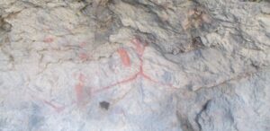
Got fairly close to the destination when the primitive road got too dicey for a rental. Hiked the last few miles. The higher I went, the more snow. The app said I was darn close as I came to a cliff. At the base of the cliff, a large cave. Scrambled up to the cave and found some signs, in red, as well as black markings. There was no trash, but I knew I wasn’t the first modern person to be there.
If these marks were anything, they were pictographs (paintings), not petroglyphs (rock carvings). It was possible that petroglyphs were elsewhere, perhaps on top of the cliff, but the GPS altitude reading suggested that the cave was the correct elevation. It would be hard work climbing up to the top of the cliff. I am old. I was far from anything.
I took the bird in hand, sat around in the mouth of the cave, listening to the mountains, bathing in sunlight. I was going to try to find a hot spring that afternoon.
Wow John – I had no idea you were searching and wandering like this. It’s hard to take a risk to find an outback place where your body might be on the line to get you there. I felt the adventure in what you wrote, but more… something about opening to mystery.
Thanks, Mimi.
Trolling around in the desert was one of the highlights of the process.
This doesn’t surprise me. You always liked wandering and mysteries